Potem Falls
California · 70-foot drop · Shasta-Trinity National Forest · Last verified 2026-05-23
Today at Potem Falls: clear, 63°F.
Right now
Overnight
63°F
Clear
Tuesday
97°F
Sunny
Today's daylight
Sunrise 6:00 AM · Sunset 8:28 PM · 14h 28m
Snapshot built 7m ago. Sources: NWS STO.
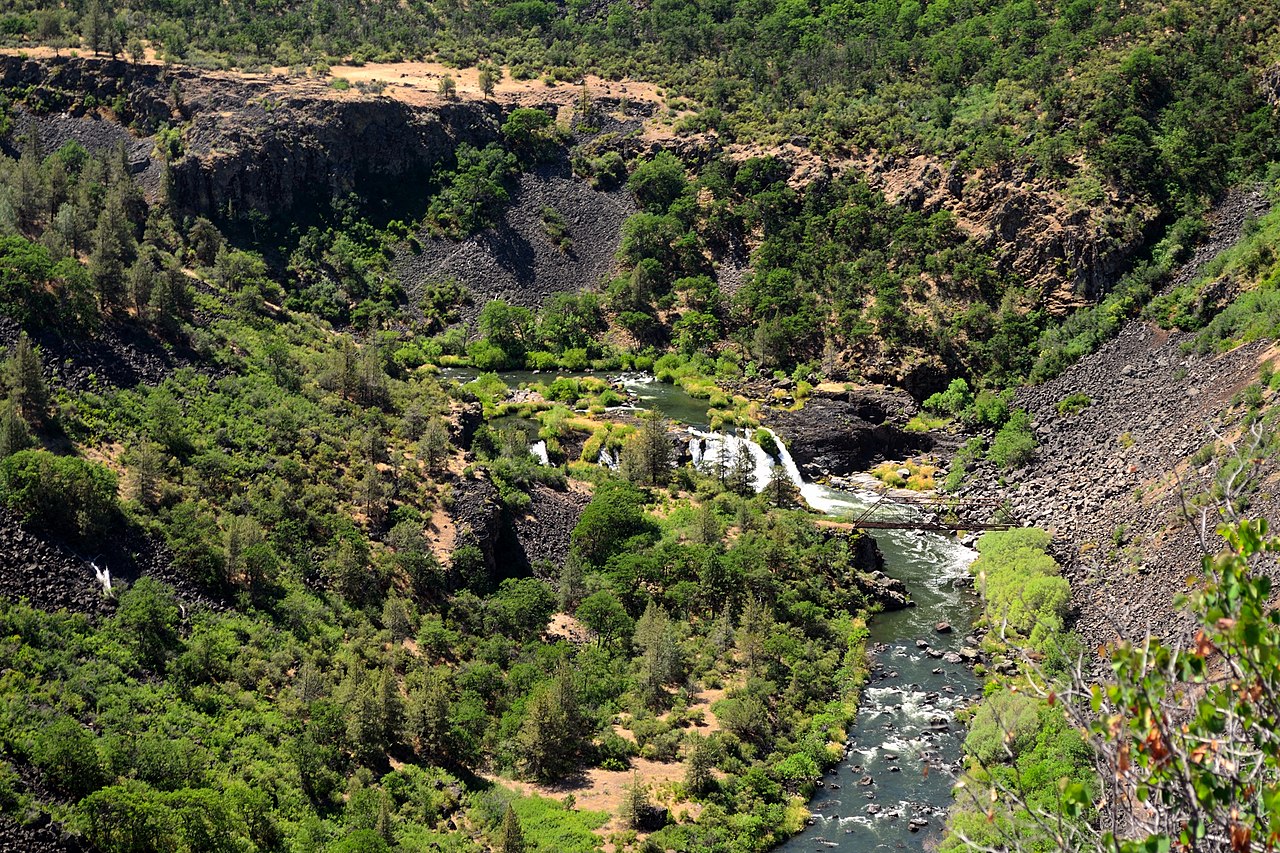
Potem Falls is a 70-foot plunge on Potem Creek, dropping into one of Shasta County's deepest and most beloved swimming holes. The 0.6-mile round trip from Fenders Ferry Rd is short but steep, with a narrow ledge that needs proper shoes. Summer is prime — clear, warm pool with room to swim. Forest Road 27 to the trailhead is gravel and gets rough after rain.
The trail
0.6 miles each way, rated easy with 140 feet of elevation gain. Trailhead pullout on Fenders Ferry Rd (FR-27), about 3 mi off CA-299 east of Round Mountain. Free.
Is the water flowing right now?
Most waterfall sites don't tell you this. The waterfall itself is almost never gauged, but a USGS streamgage in the same watershed can tell you whether snowmelt has started, peaked, or run dry.
USGS gage 11365000 · 1.4 mi away
PIT R NR MONTGOMERY CREEK CA
View live discharge data →
Compare to nearby falls
If this one isn't the right fit, here's how it stacks up against the closest documented falls. Every column is filterable on the site — not buried in 13,000 reviews.
| Waterfall | Distance | Height | Trail | Dogs | Fee |
|---|---|---|---|---|---|
| Potem Falls (this page) | — | 70 ft | easy · 0.6 mi | Y | Free |
| Three Falls | 5 mi | — | — | — | — |
| Hatchet Creek Falls | 5 mi | — | — | Y | Free |
| Montgomery Creek Falls | 5 mi | — | — | — | — |
| Hatchet Falls | 7 mi | — | — | — | — |
| Lion Slide Falls | 7 mi | — | — | — | — |
Related waterfalls
Similar height (~70 ft)
- Angel Falls70 ft
- Howlaak Falls70 ft
- Paradise Falls70 ft
- Sunset Falls70 ft
- Boulder Falls69 ft
Same best season in California
- Illilouette Fall370 ft
- Mist Falls45 ft
- Seven Teacups200 ft
- Carlon Falls35 ft
Questions visitors ask about Potem Falls
Answers built from our structured data. If a question isn't here, the fact is unverified — we'd rather omit than guess.
How tall is Potem Falls?
Potem Falls is 70 feet (21 m) tall. Height is sourced from USFS Shasta-Trinity.
Is Potem Falls in a national or state park?
Yes — Potem Falls is inside Shasta-Trinity National Forest. See the park page for fees, hours, and current conditions.
Can I bring my dog to Potem Falls?
Yes — dogs are allowed (Shasta-Trinity National Forest permits leashed dogs in most areas). Always leash and pack out waste.
Can you swim at Potem Falls?
Potem Falls has a swimmable area. The deep, broad pool at the base is one of the best swimming holes in Shasta County — clear, surprisingly warm in summer, with room to splash around.
When is the best time to visit Potem Falls?
Peak flow is typically June, July, August, September. Season-wise: summer, fall. Snowmelt and recent rain affect day-to-day volume.
Is there a fee to visit Potem Falls?
No entrance fee. Shasta-Trinity National Forest is free to access. Some trailheads may charge a parking fee separately.
How far is Potem Falls from a major city?
Potem Falls is 6 miles from Round Mountain (about 8 minutes' drive).
More waterfalls in California
Where it is
40.8395, -122.0286
Sources and live status
Where we got the data, and where to check current conditions before you drive.
Official land manager
https://www.fs.usda.gov/r05/shasta-trinity/recreation/trails/potem-falls-trail
GeoNames (5569762)
https://www.geonames.org/5569762/
Last verified by Fallspots: 2026-05-23
Been there?
Marina and Theo verify pages one road trip at a time. If you've been to Potem Falls recently, your local knowledge improves the page for everyone. Pick the kind of contribution that fits — every email lands in our inbox and gets read (and credited when we publish).
Add a tip
Something we should know — best time, parking trick, that hidden viewpoint.
Share a photo
Have a CC-licensed image on Wikimedia or Flickr? Send the link.
Report a fix
Wrong height, closed trail, broken link — tell us what we got wrong.
We don't collect your email. Replies go directly to hello@fallspots.com.