A structured directory of US waterfalls
Where the falls are. What they're like. Whether they're worth it.
The structured directory of 5,574 US waterfalls across 50 states. We treat them as data — so you can ask: which dog-friendly, drive-by waterfalls are within 90 minutes of me?
507 under live monitoring · 25 at peak flow · 119 going dry today · 41 closed
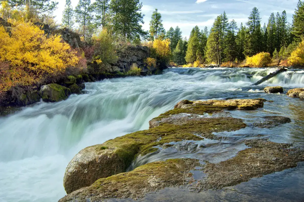
Photo of the day · 2026-07-28
Dillon Falls
Oregon
Or jump to
Queries no other waterfall site can answer
Structured beats prose
Every field on every waterfall page is queryable. Three live examples from our dataset.
Over 500 feet tall
height_ft > 500
41 matches
- Sulphide Creek FallsWashington · 3,937 ft
- East Snow Mountain FallsCalifornia · 2,200 ft
- Horsetail FallCalifornia · 2,133 ft
- Snow Creek FallsCalifornia · 2,133 ft
Inside a National Park
park_type == "national_park"
421 matches
- Bridalveil FallCalifornia · 620 ft
- Illilouette FallCalifornia · 370 ft
- Lower Yosemite FallCalifornia · 320 ft
- Nevada FallCalifornia · 594 ft
Trail tagged in OSM + has a photo
trail_evidence.has_nearby_trail == true AND images.length > 0
313 matches
- Bridalveil FallCalifornia · 620 ft
- Illilouette FallCalifornia · 370 ft
- Lower Yosemite FallCalifornia · 320 ft
- Nevada FallCalifornia · 594 ft
5,574 waterfalls indexed across 50 states, cross-referenced between OpenStreetMap and USGS GNIS. The top 500 by popularity get live USGS streamflow + NOAA forecast + air quality + sunrise/sunset on every page, refreshed every 6 hours.
All 5,574 on one map
Filter the list →Every named waterfall in our dataset. Zoom in until clusters break apart, then click a pin for the page.
Right now across the dataset
507 waterfalls under live monitoring
USGS streamflow, NOAA forecasts, NPS alerts, and wildfire proximity refreshed every 3 days. Last update: 2026-07-28.
25
at peak flow
- Ribbon Falls — 9,260 cfs
- Mingo Falls — 810 cfs
- Bald River Falls — 494 cfs
+ Show 22 more →− Hide
- Hooker Falls — 420 cfs
- Triple Falls — 420 cfs
- Meigs Falls — 411 cfs
- Chenuis Falls — 346 cfs
- Crabtree Falls — 285 cfs
- Roaring Fork Falls — 285 cfs
- Spoon Creek Falls — 269 cfs
- Linville Falls — 150 cfs
- Canes Creek Cascades;Cane Creek Falls — 147 cfs
- Coon Creek Falls — 147 cfs
- Fall Creek Falls — 147 cfs
- Piney Creek Falls — 147 cfs
- Virgin Falls — 147 cfs
- Hemlock Falls — 98 cfs
- Ozone Falls — 98 cfs
- Toketee Falls — 90 cfs
- Noccalula Falls — 81 cfs
- Titacoclos Falls — 56 cfs
- Catawba Falls — 54 cfs
- Douglas Falls — 54 cfs
- Glassmine Falls — 54 cfs
- Walker Falls — 54 cfs
119
going dry today
- Akaiyan Falls — 2,060 cfs (bottom 0%)
- Angeline Falls — 316 cfs (bottom 0%)
- Apikuni Falls — 129 cfs (bottom 0%)
+ Show 47 more →− Hide
- Beaver Chief Falls — 2,060 cfs (bottom 0%)
- Big Heart Falls — 316 cfs (bottom 0%)
- Bird Woman Falls — 129 cfs (bottom 0%)
- Chagoopa Falls — 0.8 cfs (bottom 0%)
- Chush Falls — 7.3 cfs (bottom 0%)
- Coopey Falls — 11.6 cfs (bottom 0%)
- Copper Lake Falls — 316 cfs (bottom 0%)
- Dawn Mist Falls — 129 cfs (bottom 0%)
- Deer Lick Falls — 36.8 cfs (bottom 0%)
- Denny Camp Falls — 37 cfs (bottom 0%)
- Double Falls — 953 cfs (bottom 0%)
- Drake Falls — 953 cfs (bottom 0%)
- Drury Falls — 197 cfs (bottom 0%)
- Elowah Falls — 48.3 cfs (bottom 0%)
- Fairy Falls — 11.6 cfs (bottom 0%)
- Falls Creek Falls — 255 cfs (bottom 0%)
- Feather Plume Falls — 129 cfs (bottom 0%)
- Feather Woman Falls — 2,060 cfs (bottom 0%)
- Franklin Falls — 37 cfs (bottom 0%)
- Grinnell Falls — 129 cfs (bottom 0%)
- Grizzly Falls — 0.8 cfs (bottom 0%)
- Hindostan Falls — 3,900 cfs (bottom 0%)
- Ipasha Falls — 129 cfs (bottom 0%)
- Johnson Shut-Ins — 0.7 cfs (bottom 0%)
- Keekwulee Falls — 37 cfs (bottom 0%)
- Koosah Falls — 162 cfs (bottom 0%)
- Latourell Falls — 391 cfs (bottom 0%)
- Lava Canyon Falls — 140 cfs (bottom 0%)
- Loowit Falls — 140 cfs (bottom 0%)
- Louis Creek Falls — 76.7 cfs (bottom 0%)
- Lower Carp Falls — 111 cfs (bottom 0%)
- Lower Copper Falls — 316 cfs (bottom 0%)
- Lower Foss River Falls — 316 cfs (bottom 0%)
- Lower Lewis River Falls — 140 cfs (bottom 0%)
- Lower North Falls — 953 cfs (bottom 0%)
- Lower South Falls — 953 cfs (bottom 0%)
- Malachite Falls — 316 cfs (bottom 0%)
- Manabezho Falls — 18.4 cfs (bottom 0%)
- Manido Falls — 18.4 cfs (bottom 0%)
- Middle Copper Falls — 316 cfs (bottom 0%)
- Middle North Falls — 953 cfs (bottom 0%)
- Mill Creek Falls — 585 cfs (bottom 0%)
- Mina Sauk Falls — 0.7 cfs (bottom 0%)
- Mist Falls — 11.6 cfs (bottom 0%)
- Mist Falls — 0.8 cfs (bottom 0%)
- Monument Falls — 129 cfs (bottom 0%)
- Morgan Falls — 111 cfs (bottom 0%)
41
under NPS closure alerts
- Annie Falls — East Rim Drive is CLOSED from Park Headquarters to Phantom Ship Overlook
- Bannock Falls — Death Canyon Trailhead Construction Closure
- Bechler Falls — Biscuit Basin Closed Due to Hydrothermal Explosion
+ Show 38 more →− Hide
- Berdeen Falls — Campfire Ban in All Portions of the Park Complex Begins June 29
- Calypso Cascades — A Fire Ban (Stage 2 Fire Restrictions) Are In Effect
- Cascades of the Firehole — Biscuit Basin Closed Due to Hydrothermal Explosion
- Chasm Falls — A Fire Ban (Stage 2 Fire Restrictions) Are In Effect
- Cleft Falls — Death Canyon Trailhead Construction Closure
- Columbine Cascade — Death Canyon Trailhead Construction Closure
- Crystal Falls — Biscuit Basin Closed Due to Hydrothermal Explosion
- Depot Creek Falls — Campfire Ban in All Portions of the Park Complex Begins June 29
- Duwee Falls — East Rim Drive is CLOSED from Park Headquarters to Phantom Ship Overlook
- Fairy Falls — Biscuit Basin Closed Due to Hydrothermal Explosion
- Firehole Falls — Biscuit Basin Closed Due to Hydrothermal Explosion
- Gibbon Falls — Biscuit Basin Closed Due to Hydrothermal Explosion
- Green Lake Falls — Campfire Ban in All Portions of the Park Complex Begins June 29
- Hidden Falls — Death Canyon Trailhead Construction Closure
- Iris Falls — Biscuit Basin Closed Due to Hydrothermal Explosion
- Kepler Cascades — Biscuit Basin Closed Due to Hydrothermal Explosion
- Lewis Falls — Biscuit Basin Closed Due to Hydrothermal Explosion
- Lower Yellowstone Falls — Biscuit Basin Closed Due to Hydrothermal Explosion
- Marymere Falls — Mora Road Closed for Essential Repairs
- Meigs Falls — Single-Lane Closures on Gatlinburg Spur
- Moose Falls — Biscuit Basin Closed Due to Hydrothermal Explosion
- Mystic Falls — Biscuit Basin Closed Due to Hydrothermal Explosion
- Plaikni Falls — East Rim Drive is CLOSED from Park Headquarters to Phantom Ship Overlook
- Ribbon Cascade — Death Canyon Trailhead Construction Closure
- Rustic Falls — Biscuit Basin Closed Due to Hydrothermal Explosion
- Shoshoko Falls — Death Canyon Trailhead Construction Closure
- Silver Cord Cascade — Biscuit Basin Closed Due to Hydrothermal Explosion
- Sol Duc Falls — Mora Road Closed for Essential Repairs
- Sulphide Creek Falls — Campfire Ban in All Portions of the Park Complex Begins June 29
- Terraced Falls — Biscuit Basin Closed Due to Hydrothermal Explosion
- Tom Branch Falls — Single-Lane Closures on Gatlinburg Spur
- Tower Fall — Biscuit Basin Closed Due to Hydrothermal Explosion
- Undine Falls — Biscuit Basin Closed Due to Hydrothermal Explosion
- Union Falls — Biscuit Basin Closed Due to Hydrothermal Explosion
- Upper Yellowstone Falls — Biscuit Basin Closed Due to Hydrothermal Explosion
- Virginia Cascades — Biscuit Basin Closed Due to Hydrothermal Explosion
- Wilderness Falls — Death Canyon Trailhead Construction Closure
- Wraith Falls — Biscuit Basin Closed Due to Hydrothermal Explosion
10
with AQI > 100 (unhealthy for sensitive groups). Check the per-fall page before driving.
What we track per waterfall
Most of the web treats this list as prose. We treat it as fields — eighteen of them, grouped so the page can answer real questions instead of trying to be everything at once.
The drop
- Height from multiple sources
- Discrepancies flagged when they disagree
- Type (plunge / horsetail / tiered)
- Number of drops
Location
- Coordinates and elevation
- Containing park or wilderness
- Nearest city + drive time
- Watercourse it sits on
Access
- Trail distance and Class 1–5 difficulty
- Elevation gain in feet
- Dog policy, kid age, wheelchair
- Parking, restrooms, fees
Conditions
- Best months for flow and crowding
- Swimmable (with explicit reason if not)
- Known fatalities + specific warnings
- Live USGS streamflow + NOAA forecast
Plus: external links to Wikidata QID, GeoNames ID, Wikipedia, and the official park page.
Recent guides
All guides →Long-form pieces on finding, photographing, and not dying at waterfalls.
Stay in the loop
Get an email when we publish something worth driving to.
Roughly one note a month — new state guides, seasonal flow reports, and occasionally a road-trip writeup. No tracking pixels, no junk.
Powered by Beehiiv. We never share the list. Unsubscribe in one click.
Side-by-side
Comparisons between famous waterfalls. Same data we use on each page, laid out side-by-side so you can decide which is worth your weekend.
American Falls vs Bridal Veil Falls
NY · NY · 0 mi apart
American Falls vs Chittenango Falls
NY · NY · 163 mi apart
American Falls vs Delphi Falls Lower
NY · NY · 161 mi apart
American Falls vs Delphi Falls Upper
NY · NY · 161 mi apart
American Falls vs Diamond Notch Falls
NY · NY · 253 mi apart
American Falls vs Eternal Flame Falls
NY · NY · 31 mi apart
Browse by state
All 50 states. Sorted by waterfall count.
North Carolina
818
Washington
481
New York
389
Oregon
384
California
376
South Carolina
233
Michigan
227
Arkansas
203
Tennessee
203
Pennsylvania
174
Maine
159
Connecticut
139
Montana
127
New Hampshire
125
Colorado
124
Hawaii
99
Wyoming
96
Minnesota
83
Wisconsin
82
Kentucky
81
Idaho
80
Utah
78
Virginia
75
Georgia
69
Ohio
67
Vermont
59
Alabama
55
Arizona
54
Massachusetts
50
Texas
47
Alaska
46
Illinois
39
West Virginia
34
Oklahoma
32
Indiana
30
New Jersey
25
New Mexico
21
Missouri
19
Maryland
17
Nevada
12
Rhode Island
11
South Dakota
11
Nebraska
10
Kansas
9
Iowa
6
Florida
5
Mississippi
4
Louisiana
3
District of Columbia
1
North Dakota
1