Silver Cord Cascade
Wyoming · 1,214-foot drop · Yellowstone National Park · Last verified 2026-05-14
Today at Silver Cord Cascade: mostly clear, 46°F.
Right now
Overnight
46°F
Mostly Clear
Friday
78°F
Sunny then Slight Chance Showers And Thunderstorms
Today's daylight
Sunrise 5:45 AM · Sunset 9:08 PM · 15h 22m
Other park alerts
- Select rivers closed to fishing daily, 2 p.m. to sunrise(Information)
- Traffic Delays - Gibbon River Bridge(Information)
- Biscuit Basin Closed Due to Hydrothermal Explosion(Park Closure)
Snapshot built 6m ago. Sources: NWS RIW.
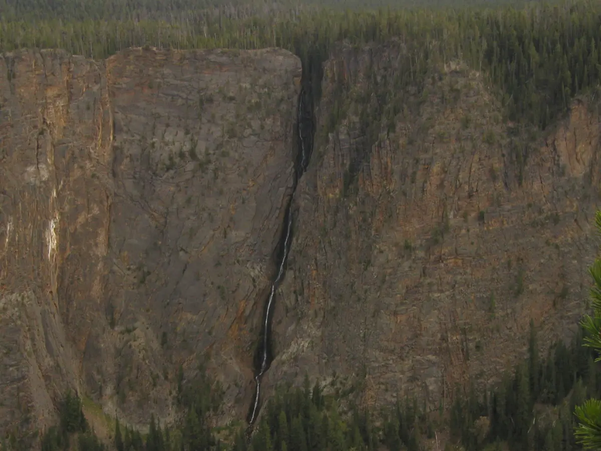
Silver Cord Cascade is the tallest waterfall in Yellowstone National Park, dropping 1,214 feet down the north wall of the Grand Canyon of the Yellowstone. The view is from across the canyon — there is no access to the base. The cascade is best seen from the Ribbon Lake Trail, a short walk from Glacial Boulder. Flow peaks in May and June with snowmelt and thins steadily through summer.
Silver Cord Cascade is a horsetail type waterfall on Surface Creek, a tributary of the Yellowstone River in Yellowstone National Park. Surface Creek flows out of Ribbon Lake off the South rim of the Grand Canyon of the Yellowstone and plunges 1,200 feet (370 m) to the Yellowstone River. It is considered one of the tallest waterfalls in Yellowstone.
A short history
Named in 1885 by the second Hayden Survey for its thin, vertical appearance against the canyon's yellow rhyolite walls.
The trail
1.2 miles each way, rated easy with 150 feet of elevation gain. Glacial Boulder pullout on North Rim Drive
Why the waterfall is there
Drops down the yellow rhyolite wall that gives Yellowstone its name. The rhyolite was erupted about 484,000 years ago during the formation of the Yellowstone Caldera. The Yellowstone River cut the canyon through the rhyolite after caldera collapse and subsequent hydrothermal alteration weakened the rock — the yellow color is from iron-stained hydrothermally altered rhyolite.
- Rock type
- Hydrothermally altered rhyolite
- Formation age
- ~484,000 years (Lava Creek Tuff)
Source: USGS Yellowstone Volcano Observatory + NPS GRI
Compare to nearby falls
If this one isn't the right fit, here's how it stacks up against the closest documented falls. Every column is filterable on the site — not buried in 13,000 reviews.
| Waterfall | Distance | Height | Trail | Dogs | Fee |
|---|---|---|---|---|---|
| Silver Cord Cascade (this page) | — | 1,214 ft | easy · 1.2 mi | N | $35 |
| Lower Yellowstone Falls | 2 mi | 308 ft | — | N | — |
| Crystal Falls | 3 mi | — | — | N | — |
| Upper Yellowstone Falls | 3 mi | 108 ft | — | N | — |
| Virginia Cascades | 10 mi | 59 ft | — | N | — |
| Tower Fall | 12 mi | 131 ft | — | N | — |
Side-by-side comparisons
Silver Cord Cascade compared head-to-head with other documented falls — height, access, fees, dogs, swimmability in one row each.
Related waterfalls
Similar height (~1214 ft)
- Chagoopa Falls1,201 ft
- Otter Falls1,200 ft
- Lehamite Falls1,181 ft
- Royal Arch Cascade1,247 ft
- Big Heart Falls1,262 ft
Same best season in Wyoming
- Gibbon Falls84 ft
- Hidden Falls100 ft
- Kepler Cascades150 ft
- Moose Falls30 ft
- Porcupine Falls75 ft
Questions visitors ask about Silver Cord Cascade
Answers built from our structured data. If a question isn't here, the fact is unverified — we'd rather omit than guess.
How tall is Silver Cord Cascade?
Silver Cord Cascade is 1,214 feet (370 m) tall. Height is sourced from Wikipedia.
Is Silver Cord Cascade in a national or state park?
Yes — Silver Cord Cascade is inside Yellowstone National Park. See the park page for fees, hours, and current conditions.
Can I bring my dog to Silver Cord Cascade?
No — dogs are not allowed on trails here. Most National Park trails prohibit pets to protect wildlife. Service animals are an exception per ADA.
Can you swim at Silver Cord Cascade?
No — swimming is not safe or not allowed at Silver Cord Cascade. viewing only from rim trail across the canyon
When is the best time to visit Silver Cord Cascade?
Peak flow is typically May, June, July, August. Season-wise: spring, summer. Snowmelt and recent rain affect day-to-day volume.
Is there a fee to visit Silver Cord Cascade?
Yes — entry costs around $35. Most Yellowstone National Park entrances accept the America the Beautiful annual pass.
How far is Silver Cord Cascade from a major city?
Silver Cord Cascade is 4 miles from Canyon Village (about 10 minutes' drive).
More waterfalls in Wyoming
Where it is
44.7261, -110.4517
Sources and live status
Where we got the data, and where to check current conditions before you drive.
Official land manager
https://www.nps.gov/yell/
Wikipedia
https://en.wikipedia.org/wiki/Silver_Cord_Cascade
Wikidata (Q7515928)
https://www.wikidata.org/wiki/Q7515928
GeoNames (5838389)
https://www.geonames.org/5838389/
Yellowstone road status
https://www.nps.gov/yell/planyourvisit/parkroads.htm
Yellowstone current conditions
https://www.nps.gov/yell/planyourvisit/conditions.htm
Last verified by Fallspots: 2026-05-14
Been there?
Marina and Theo verify pages one road trip at a time. If you've been to Silver Cord Cascade recently, your local knowledge improves the page for everyone. Pick the kind of contribution that fits — every email lands in our inbox and gets read (and credited when we publish).
Add a tip
Something we should know — best time, parking trick, that hidden viewpoint.
Share a photo
Have a CC-licensed image on Wikimedia or Flickr? Send the link.
Report a fix
Wrong height, closed trail, broken link — tell us what we got wrong.
We don't collect your email. Replies go directly to hello@fallspots.com.