Linton Falls
Oregon · 615-foot drop · Three Sisters Wilderness · Last verified 2026-05-14
Today at Linton Falls: clear, 45°F.
Right now
Overnight
45°F
Clear
Friday
70°F
Sunny
Today's daylight
Sunrise 5:33 AM · Sunset 8:51 PM · 15h 18m
Snapshot built 8m ago. Sources: NWS PQR.
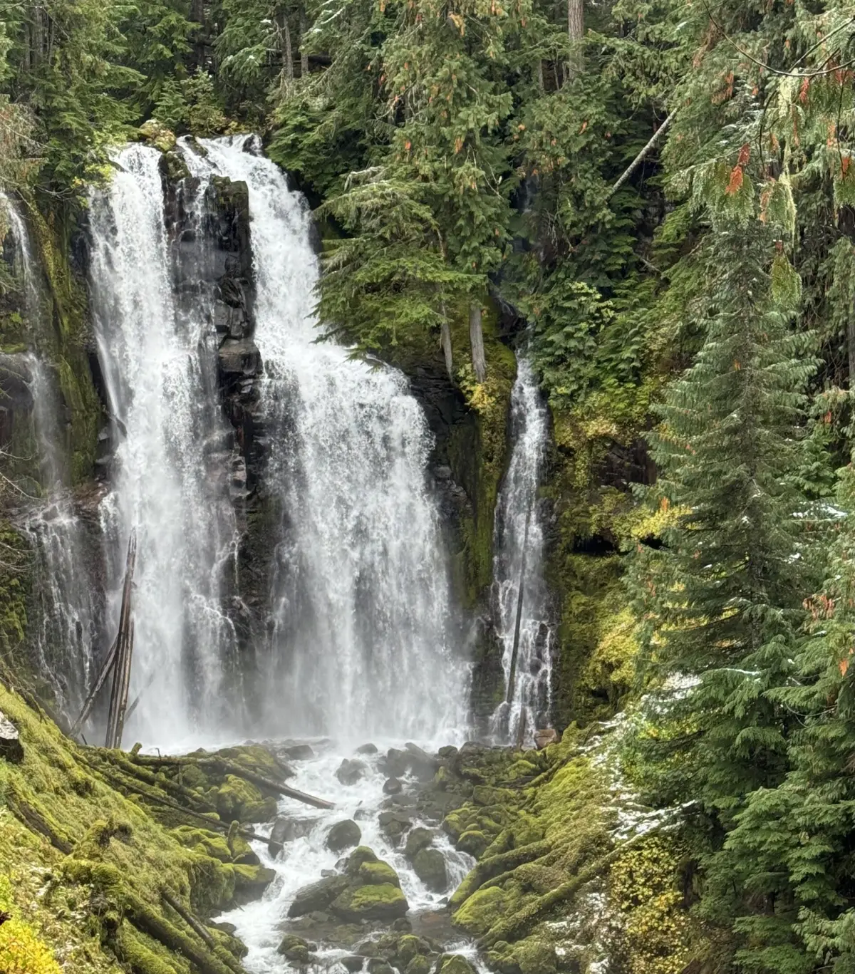
Linton Falls drops 615 feet in eight tiers down Linton Creek in the Three Sisters Wilderness. The tallest single tier — the lowest drop — is 85 feet. The hike in is roughly 5.2 miles each way from the Obsidian Trailhead, with 900 feet of elevation gain and several creek crossings. Permits via recreation.gov are required to enter the wilderness in season.
Linton Falls is a multi-step waterfall of 8 tiers located in the heart of the Three Sisters Wilderness, just east of the North Sister volcano on Oregon Route 242 in Lane County, in the U.S. state of Oregon. It totals 615 feet fall in eight drops, the tallest and last drop is 85 feet.
A short history
Named for Linton Creek, charted by USFS surveys in the early 20th century.
The trail
5.2 miles each way, rated moderate with 900 feet of elevation gain. Obsidian Trailhead off Highway 242 (closed in winter)
Why the waterfall is there
Linton Creek cuts down through a stack of basalt flows on the east flank of the High Cascades. The eight-tier structure tracks the contacts between individual flows — each step is where a softer flow top meets a harder flow base, producing the characteristic stepped profile common to High Cascade waterfalls.
- Rock type
- High Cascades basalt and basaltic andesite
- Formation age
- Pleistocene to Holocene (<2 million years)
Source: Oregon Department of Geology and Mineral Industries (DOGAMI)
Compare to nearby falls
If this one isn't the right fit, here's how it stacks up against the closest documented falls. Every column is filterable on the site — not buried in 13,000 reviews.
| Waterfall | Distance | Height | Trail | Dogs | Fee |
|---|---|---|---|---|---|
| Linton Falls (this page) | — | 615 ft | moderate · 5.2 mi | Y | $6 |
| Upper Proxy Falls | 2 mi | 129 ft | — | Y | Free |
| Proxy Falls | 2 mi | 226 ft | — | Y | Free |
| Obsidian Falls | 3 mi | — | — | — | — |
| Indian Hole Falls | 5 mi | — | — | — | — |
| Honey Creek Falls | 5 mi | — | — | — | — |
Related waterfalls
Similar height (~615 ft)
- Bridalveil Fall620 ft
- Bridal Veil Falls607 ft
- Wildcat Falls623 ft
- Malachite Falls600 ft
- Cape Horn Falls597 ft
Same best season in Oregon
- Diamond Creek Falls90 ft
- Tamanawas Falls108 ft
- South Umpqua Falls15 ft
Questions visitors ask about Linton Falls
Answers built from our structured data. If a question isn't here, the fact is unverified — we'd rather omit than guess.
How tall is Linton Falls?
Linton Falls is 615 feet (187 m) tall. Source heights disagree by source — see the discrepancy box on the page.
Is Linton Falls in a national or state park?
Yes — Linton Falls is inside Three Sisters Wilderness. See the park page for fees, hours, and current conditions.
Can I bring my dog to Linton Falls?
Yes — dogs are allowed (Three Sisters Wilderness permits leashed dogs in most areas). Always leash and pack out waste.
Can you swim at Linton Falls?
No — swimming is not safe or not allowed at Linton Falls. cold glacial water; strong current; no formal swim area
When is the best time to visit Linton Falls?
Peak flow is typically July, August, September. Season-wise: summer, early_fall. Snowmelt and recent rain affect day-to-day volume.
Is there a fee to visit Linton Falls?
Yes — entry costs around $6. Most Three Sisters Wilderness entrances accept the America the Beautiful annual pass.
How far is Linton Falls from a major city?
Linton Falls is 64 miles from Eugene (about 95 minutes' drive).
More waterfalls in Oregon
Where it is
44.1598, -121.8867
Sources and live status
Where we got the data, and where to check current conditions before you drive.
Official land manager
https://www.fs.usda.gov/willamette
Wikipedia
https://en.wikipedia.org/wiki/Linton_Falls_(Oregon)
Wikidata (Q30605376)
https://www.wikidata.org/wiki/Q30605376
GeoNames (5736752)
https://www.geonames.org/5736752/
Three Sisters Wilderness permits (recreation.gov)
https://www.recreation.gov/permits/4099589
Highway 242 (McKenzie Pass) status
https://tripcheck.com/
Last verified by Fallspots: 2026-05-14
Been there?
Marina and Theo verify pages one road trip at a time. If you've been to Linton Falls recently, your local knowledge improves the page for everyone. Pick the kind of contribution that fits — every email lands in our inbox and gets read (and credited when we publish).
Add a tip
Something we should know — best time, parking trick, that hidden viewpoint.
Share a photo
Have a CC-licensed image on Wikimedia or Flickr? Send the link.
Report a fix
Wrong height, closed trail, broken link — tell us what we got wrong.
We don't collect your email. Replies go directly to hello@fallspots.com.